Warp It Asset Record
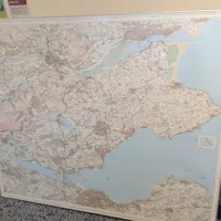
Large Geographic Map of Fife
WI-183736
Scan for live record
WI-183736
- Category
- Stationery / Geography maps
- Condition
- Good
- Quantity
- 1
- Status
- Active
- Location
- Fife
- Postcode
- KY8 5RR
- Organisation
- NHS Fife
- Date added
- 21 Oct 2026
- Est. value
- £85
- Est. weight
- 2.50 kg
A pre-2017 large-scale wall or reference map displaying the Fife and surrounding regions with detailed topographical features, road networks, and coastal features shown in multiple colours. The map appears to be a professional cartographic reference suitable for educational, planning, or administrative use. Presented mounted on a frame with protective border.
Generated 21 Oct 2026 14:46 · warp-it.co.uk